Mozambique Zambezi River

..
"Experience the Wonder of the Zambezi River"
The Zambezi River, also spelled as Zambeze and Zambesi, is a mighty African river that boasts several impressive titles. It holds the distinction of being Africa's fourth-longest river while simultaneously claiming to be its longest east-flowing waterway. The most notable feature of this majestic body of water is undoubtedly Victoria Falls - an iconic natural wonder known worldwide for its awe-inspiring beauty.
But there's more to the Zambezi than just one breathtaking waterfall; it has plenty else going on too! For starters, did you know that this remarkable river spans over 1,390,000 square kilometers (540k sq miles)? That means it covers nearly half the size of another famous African landmark: the Nile!
The journey along which this incredible aquatic giant flows starts in Zambia before winding through Angola and Namibia until finally reaching Botswana's northern border. From here onwards into Zimbabwe then Mozambique where it empties out into none other than Indian Ocean itself.
Aside from providing stunning scenery at every turn with cascading falls like Chavuma Falls or Ngonye near Sioma Western Zambia- these waters are responsible for powering two significant hydroelectric power sources within their banks – Kariba Dam located between both countries' borders (Zambia & Zimbabwe)and Cahora Bassa Dam supplying energy not only locally but even neighboring South Africa benefits from them too! Additionally smaller stations can be found nearby such as those situated close by Kalene Hill Ikelenge Districts right alongside Victoria Falls themselves making sure no area goes without electricity when needed most.
It's hard not to appreciate all that makes up what we call "the Mighty" Zambezi River given how much life thrives around her shores thanks largely due environmental diversity fostered throughout centuries gone past ensuring future generations will continue enjoying everything she offers today tomorrow beyond!
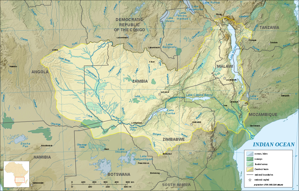
Zambezi River Bassin
The mighty Zambezi River originates in Zambia and meanders through a staggering 2,574 kilometers (1,599 miles) of the south-central African plateau. Finally reaching its destination at the Indian Ocean via an extensive delta in Mozambique where it deposits water and sediment along its path. This awe-inspiring river is not to be missed on any journey through Africa!

Wild Zambezi and powerful waterfalls
The Zambezi river in Mozambique
The Zambezi Delta is located in Mozambique, on the eastern coast of Africa. It is situated at the mouth of the Zambezi River, where the river empties into the Indian Ocean. The delta covers an area of approximately 10,000 square kilometers and is characterized by a network of channels, islands, and wetlands. The delta is an important ecological and economic resource for Mozambique, providing habitat for a variety of species and supporting a range of economic activities, including fishing, agriculture, and tourism.

Bridge Armado Emilia Guebuza over the Zambeze river
The north, center and south of Mozambique have been connected by land for the first time in the country's history, with the inauguration of the bridge over the Zambezi river, one of the largest in Africa. Before the start of operation of the bridge, named after the Mozambican Head of State, Armando Emílio Guebuza, the journey overland from one end of the country to the other ended at the crossing of the Zambezi River, more than 1,000 kilometers from Maputo. Only with degraded barges and precarious barges was it possible to cross the deep water river infested with crocodiles.
