Mozambique Geography and the African Great Rift Valley
The African Great Rift Valley: A Geological Backbone

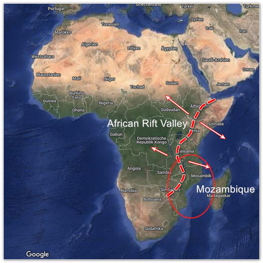
The African Great Rift Valley is a massive tectonic feature stretching over 6,000 kilometers from the Red Sea to Mozambique, formed by the divergence of the African and Arabian tectonic plates. In East Africa, it splits into the Eastern and Western Rift Valleys, with the Eastern Rift extending into Mozambique as the southernmost segment. This rift system, active for over 30 million years, has created dramatic landscapes through faulting, volcanic activity, and subsidence, resulting in rift lakes, escarpments, and elevated plateaus.
In Mozambique, the Rift Valley's influence is most evident in the northern and central regions, where it shapes the country's topography, hydrology, and ecosystems. The Rift Valley's tectonic activity has carved deep basins, uplifted plateaus, and formed inselbergs—isolated rocky hills—while influencing major water systems like Lake Niassa and the Zambezi River. This geological framework creates a diverse terrain that ranges from coastal lowlands to high plateaus and mountains, offering visitors a variety of landscapes to explore.
Mozambique's Geography in Relation to the Rift Valley
Mozambique, located in southeastern Africa, spans 801,590 km², with a 2,470 km coastline along the Indian Ocean. Its geography can be broadly divided into three zones, all influenced by the Rift Valley's southern extension:
Northern and Central Plateaus (Rift Valley Influence):
The Mozambican Plateau, covering 51% of the country, dominates the northern and central regions with altitudes between 200 and 1,000 meters. This plateau is a direct result of Rift Valley uplift, featuring medium plateaus (200–600 m) north of the 17th parallel south in provinces like Niassa, Cabo Delgado, and Nampula, and high plateaus (above 600 m) in Niassa, Nampula, Zambézia, Tete, and Manica provinces.
Lake Niassa (Rift Lake): In Niassa Province, Lake Niassa (also known as Lake Malawi) is a rift lake formed by the Rift Valley's tectonic activity. Stretching 560 km long and up to 700 m deep, it's the southernmost major lake in the Rift Valley system, hosting over 1,000 fish species, 90% of which are endemic cichlids. The Niassa Plateau borders the lake, offering visitors a chance to explore its clear waters and biodiversity.
Zambezi River (Rift-Influenced River System): The Zambezi River, flowing through Tete Province, is influenced by the Rift Valley's faulting, which has shaped its course and created features like the Zambezi Delta in Sofala Province. The river's path through the Rift Valley supports fertile floodplains, as seen in the Marávia Plateau near the Zambian border, and powers the Cahora Bassa Dam, a key hydroelectric project.
Mountains and Inselbergs: The Rift Valley's tectonic activity has uplifted mountain ranges and inselbergs. The Chimanimani Range in Manica Province, part of the high plateaus, includes Mount Binga (2,436 m), Mozambique's highest peak, offering dramatic views and hiking opportunities. Mount Namuli (2,419 m) in Zambézia, an inselberg on the medium plateaus, rises abruptly from the surrounding plains, shaped by Rift-related faulting.
Central and Southern Lowlands:
South of the Zambezi River, the Rift Valley's influence wanes, giving way to lowlands and coastal plains. The Zambezi Delta, a vast wetland in Sofala Province, is indirectly shaped by the Rift Valley's faulting, which has guided the river's flow. These lowlands transition into the Great Mozambican Plain in the south, featuring sandy beaches and dunes up to 120 meters high, as seen in areas like Maputo Province.
The Rift Valley's southernmost effects are subtle here, but its legacy is evident in the escarpments that separate the plateaus from the coastal lowlands, such as the Lebombo Mountains in southern Mozambique, reaching up to 630 meters.
Coastal Zone:
Mozambique's 2,470 km coastline, while not directly formed by the Rift Valley, is influenced by the tectonic stability of the region, which has allowed for the development of coral reefs and mangroves, particularly in the northern Quirimbas Archipelago and the southern Bazaruto Archipelago. The Rift Valley's uplift in the interior has contributed to sediment deposition along the coast, shaping deltas like the Zambezi and supporting coastal ecosystems.
Ecological and Cultural Significance
The Rift Valley's influence on Mozambique's geography creates a rich variety of ecosystems. In the north, Lake Niassa's rift basin supports over 1,000 fish species, while the Niassa Plateau's miombo woodlands in the Niassa Special Reserve host 13,000 elephants and 800 lions. The Zambezi River, guided by Rift-related faulting, sustains fertile floodplains in the Zambezi Delta, a biodiversity hotspot for waterbirds like wattled cranes. The Chimanimani Mountains, uplifted by Rift tectonics, harbor rare species like mountain elephants and Welwitsch's bat, making Parque Nacional de Chimanimani a biodiversity hotspot.
Culturally, the Rift Valley's landscapes have shaped human settlement. The Nyanja people along Lake Niassa rely on its fisheries, while the Ndau in the Chimanimani region use the mountains for spiritual ceremonies. The Zambezi River has historically been a trade route, as seen in Tete Province, where the Marávia and Angónia Plateaus support agriculture and mining, reflecting the region's economic ties to its geography.
